Explanation / uitleg
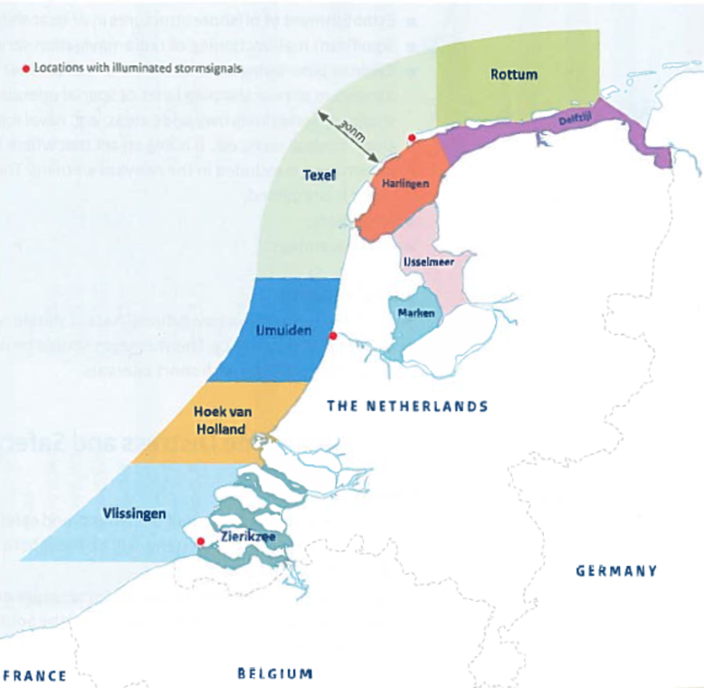
The Marifoon forecast covers the coastal waters around the Netherlands up to 30 nautical mile offshore and the greater inland waters. This area is divided into the following districts: Vlissingen, Zierikzee, Hoek van Holland, IJmuiden, Texel, Harlingen, Rottum, Delfzijl, IJsselmeer and Markermeer (see map). The Marifoon is issued four times a day and covers a period of 24 hours beginning at 00:00, 06:00, 12:00 and 18:00 UTC.The forecast contains wind warnings in force (≥6 Bft) and a forecast of: general synopsis, average wind direction and force, wind gusts (if ≥ 10 knots above average wind), weather and visibility for the districts mentioned above. For the time indication, "first" or "soon" are used for a change in the weather in the first 4 hours of the time block, "later" is used to indicate a change in the last 4 hours.
The location and direction of the low and high pressure systems and significant troughs and ridges.
Indicates the direction from which the wind is blowing. Is indicated in compass zones. The changing of the wind direction is mentioned in the forecast when the change in wind direction is expected to be 45 degrees or more.
Changeable wind direction in a low and high pressure area respectively.
Changing of the wind direction clockwise.
Changing of the wind direction anticlockwise.
The strength of the wind in Beaufort. This is the hourly average wind force. The increasing/decreasing of the wind force is mentioned in the forecast when the change in wind force is expected to be more than 1 Bft.
Is included in the Marifoon if the wind gusts are ≥ 10 knots above the hourly average wind force, e.g. if the average wind force is 4-5 Bft (11-21 knots), then the wind gusts are mentioned if they are ≥ 31 knots.
Such as rain, drizzle, hail, snow, sleet, showers, thunder and lightning, freezing rain/drizzle and ice accretion.
Visibility less than 1000 metres.
Visibility between 1 and 4 km and below 1000 m in precipitation.
Visibility between 4 and 10 km.
Visibility more than 10 km.
De Marifoonverwachting bestrijkt de kustwateren rond Nederland tot 30 nautische zeemijl uit de kust, plus de grotere binnenwateren. Dit gebied is verdeeld in de volgende gebieden: Vlissingen, Zierikzee, Hoek van Holland, IJmuiden, Texel, Harlingen, Rottum, Delfzijl, IJsselmeer en Markermeer (zie kaartje). De Marifoonverwachting wordt 4 keer per dag uitgegeven en de verwachting bestrijkt een periode van 24 uur vanaf 00:00, 06:00, 12:00 en 18:00 UTC. Het bericht bevat wind waarschuwingen (≥6 Bft) en een verwachting van: synoptische situatie, gemiddelde windkracht en windrichting, windstoten (indien ≥ 10 knopen hoger dan de gemiddelde wind), weer en zicht voor de bovengenoemde districten. Voor de tijdsaanduiding wordt ‘eerst’ of ‘spoedig’ gebruikt voor een verandering in eerste 4 uur van het tijdsblok, ‘later’ wordt gebruikt voor een verandering in de laatste 4 uur.
De locatie en bewegingsrichting van de lage- en hogedrukgebieden en significante troggen en ruggen.
Geeft de windrichting aan waar de wind vandaan komt. Is aangegeven in kompasstreken. Een verandering in de windrichting wordt aangegeven als verwacht wordt dat de windrichting 45 graden of meer verandert.
Veranderlijke windrichting in respectievelijk een lage- en hogedrukgebied.
Draaiing van de windrichting met de klok mee.
Draaiing van de windrichting tegen de klok in.
De windkracht wordt gegeven in Beaufort. Het gaat hier om de uurgemiddelde wind. Het toenemen/afnemen van de wind wordt gemeld in de verwachting als verwacht wordt dat de windverandering meer dan 1 Bft is.
Wordt gemeld in de Marifoonverwachting als verwacht wordt dat de windstoten ≥ 10 knopen boven de uurgemiddelde wind uitkomen. Bijvoorbeeld als de gemiddelde wind 4-5 Bft (11-21 knopen) is, dan worden de windstoten gemeld in de Marifoon-verwachting als verwacht wordt dat ze ≥ 31 knopen zijn.
Zoals regen, motregen, hagel, sneeuw, natte sneeuw, onweer, onderkoelde (mot)regen en ijsaanzetting.
Zicht minder dan 1000 meter.
Zicht tussen 1 en 4 km en onder 1000 m in neerslag.
Zicht tussen 4 en 10 km.
Zicht meer dan 10 km.